Loading...

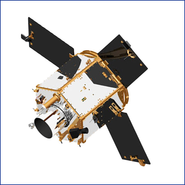
To be developed at MBRSC in Dubai, the MBZ-SAT is expected to be launched in 2024, making it the most advanced commercial satellite in the region in the field of high-resolution satellite imagery. MBZ-SAT will be equipped with an automated system for arranging images round-the-clock, ensuring that it provides the highest quality standards of satellite images intended for commercial use globally. This project will strengthen the UAE’s partnerships in the space industry between the public and private sectors. MBZ-SAT will contribute to meeting the growing commercial demand for high-resolution satellite images that will show details within an area of less than one square meter, which will be one of the most advanced features ever. The Centre will offer rapid turnaround of captured data, sharing it to users through an advanced system. This imagery solution can support a wide variety of uses within mapping and analysis, environmental monitoring, navigation, infrastructure management and disaster relief efforts, to name a few. The utility of satellite imagery in aiding and tackling natural disasters is in particular very important as they can help gauge the severity of the calamity, help plan relief efforts and aid in rebuilding efforts.

The UAE’s first nanosatellite, Nayif-1 was launched by MBRSC in collaboration with educational institutions, primarily the American University of Sharjah (AUS), as part of the sustainable space science knowledge transfer programme. The project helped to develop the space technology industry skills of Emirati engineering students and provided them with hands-on experience in the design, manufacture, integration, installation and operation of small satellites.

KhalifaSat is one of the world’s most technologically advanced remote sensing observation satellites and the first 100% designed and manufactured in the United Arab Emirates. It was launched into low Earth orbit (Approximately 613 km in altitude) in October 2018, beginning a 5-year mission to capture and transmit high-quality detailed images of Earth to the MBRSC in Dubai. These assist global governments and private organizations to monitor environmental changes, ensure effective urban management, and aid in disaster relief efforts, amongst other critical services. With five patents to its name, KhalifaSat confirms the UAE’s position alongside the world’s leading space technology manufacturing countries in humanity’s journey towards a future in space.

Design and manufacture of DubaiSat-2 began immediately following the launch of DubaiSat-1, this time with a predominantly Emirati team of engineers working alongside their South Korean associates at MBRSC’s Korean satellite manufacturing partner, Satrec Initiative. The advanced observation satellite was launched from Russia in November 2013, becoming the UAE’s second satellite in orbit. The creation of DubaiSat-2 played a major scientific role in the knowledge development journey of MBRSC and its engineers, incorporating innovative specifications and technology that surpassed the capabilities of its forerunner.

Design and manufacture of DubaiSat-2 began immediately following the launch of DubaiSat-1, this time with a predominantly Emirati team of engineers working alongside their South Korean associates at MBRSC’s Korean satellite manufacturing partner, Satrec Initiative. The advanced observation satellite was launched from Russia in November 2013, becoming the UAE’s second satellite in orbit. The creation of DubaiSat-2 played a major scientific role in the knowledge development journey of MBRSC and its engineers, incorporating innovative specifications and technology that surpassed the capabilities of its forerunner.

Skip to content